Chiang Mai, the largest city in northern Thailand, is famed for having hundreds of Buddhist temples, some of which date to the city’s founding in the 13th century. This rich history—and easy access to hiking, waterfalls, and hot springs in the surrounding highlands, as well as being the setting of a hit movie in 2012—has turned the city into a hub of tourism that hosts as many as 10 million visitors per year.
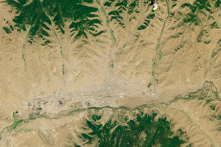
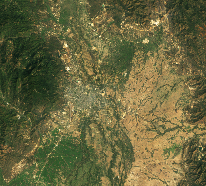
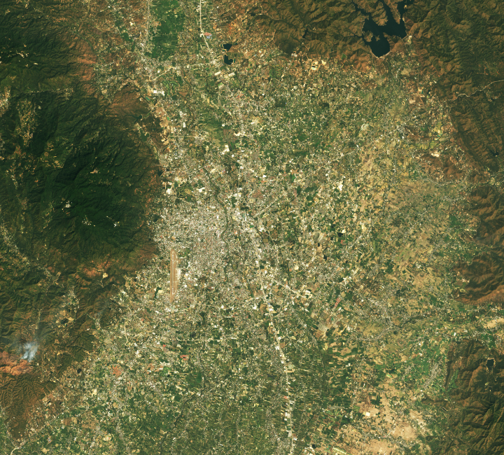
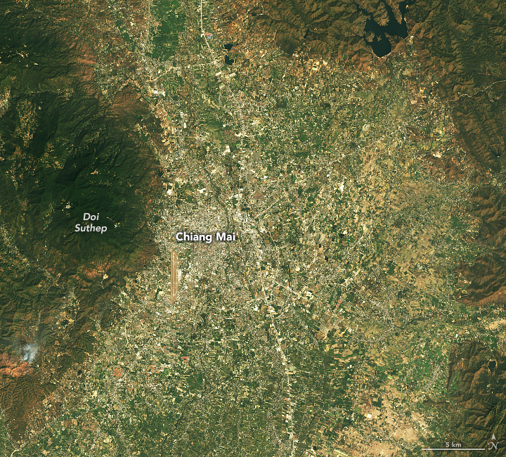
Chiang Mai’s population has grown from 191,000 in 1989 to 1.3 million in 2024, according to United Nations population data. The tourism sector, a pillar of Chiang Mai’s economy, is one of the key drivers of the rapid growth. The pair of satellite images shown above, acquired 35 years apart, highlights the growing physical footprint of the city. They were acquired with the Thematic Mapper on Landsat 4 (left) and the Operational Land Imager-2 (OLI-2) on Landsat 9 (right).
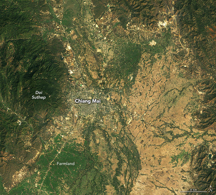
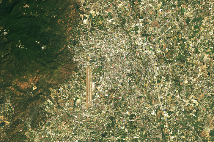
The image on the left shows Chiang Mai in February 1989, when an expanse of farmland (green and brown) surrounded the city. By February 2024, much of that open space had been replaced by development, including a system of ring roads around the city center and many new resorts, hotels, and guest houses that cater to travelers. Since the late 1980s, the number of foreign travelers visiting Chiang Mai has increased more than tenfold, with tourism fueling an estimated 100 billion baht ($2.7 billion) in economic activity in Chiang Mai in 2023. The more detailed view of the city center below highlights some of the city’s most popular tourist sites: the Wat Phra That temple on Doi Suthep and the large moat that surrounds the city’s historic center.
Tourism, however, may be affected by an increasingly noticeable problem for the booming city: hazy skies. In the dry months of March and April, levels of airborne particulate matter soar. Smoke from seasonal crop fires in the valleys and forest fires in the surrounding mountains mixes with urban emissions from traffic, industry, and other sources, forming a blanket of haze that accumulates in the Ping River valley and other valleys in the region.
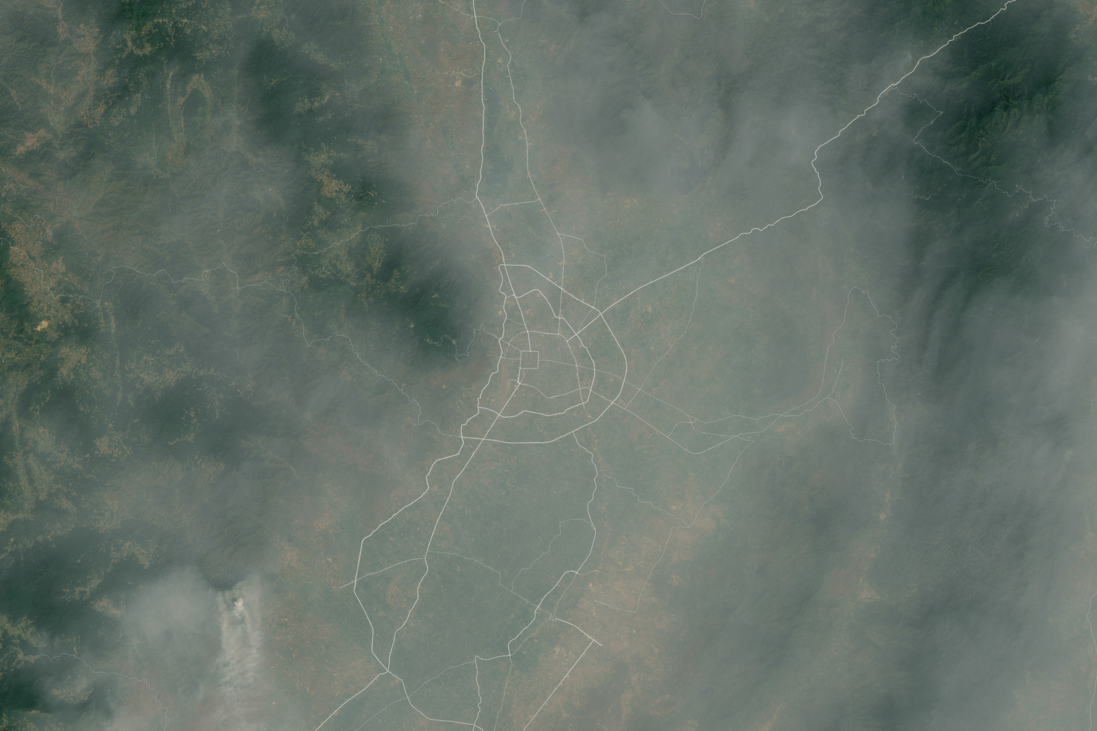
On multiple occasions in 2024, Chiang Mai topped a list of the world’s most polluted major cities kept by the Swiss technology company IQAir, according to reporting from The Straits Times and Bangkok Post. The detailed image below, acquired by the OLI on Landsat 8, shows smoke and haze enveloping the city on March 15, 2024, one of the days when ground-based sensors from Thailand’s Pollution Control Board measured soaring levels of airborne particles. A NASA AERONET station in Chiang Mai, one of several air monitoring sensors in Thailand, observed the spike in the particles as well.
What happened on March 15 is common. IQAir data shows that levels of PM2.5 (fine particulate matter) in March and April, averaged from 2017-2023, were nearly 100 micrograms per cubic meter, roughly 20 times the level considered safe by the World Health Organization. When the rains returned in May and the smoke dissipated, PM2.5 concentrations dropped to between 5 and 10 micrograms per cubic meter. For comparison, the March PM2.5 spike in Bangkok, Thailand’s capital 600 kilometers (370 miles) to the south, increased PM2.5 levels to just 38 micrograms per cubic meter.
An array of research indicates that smoke from biomass burning is the largest contributor to poor air quality in Chiang Mai during the dry season. Other contributions to hazy skies come from vehicles, as car ownership and traffic congestion have risen sharply in recent decades. Large coal-fired power plants operate in the region, and burning charcoal for cooking and heating is also a common source of air pollution.
“There is some scientific uncertainty and a number of competing narratives about what causes the haze, how bad it is, and what to do about it. But there’s no doubt that people have been burning crops and forests in this region—not just in Thailand but in neighboring countries, as well—for hundreds of years,” said Mary Mostafanezhad, a University of Hawaii geographer who studies tourism and public attitudes about the haze. “But the smoke poses a real challenge for the city. It can be horrible to breathe, and I’m hearing more and more stories of people leaving the city because of it.”
Some estimates suggest that poor air quality causes tens of thousands of hospitalizations each year and costs the city as much as 50 billion baht ($1.5 billion) in tourism revenue, according to Mostafanezhad. Hotel occupancy rates have dropped by as much as 50 percent during the smokiest months in the past, according to Reuters. Meanwhile, data from satellites and ground-based stations indicate skies have gotten hazier since 2005.

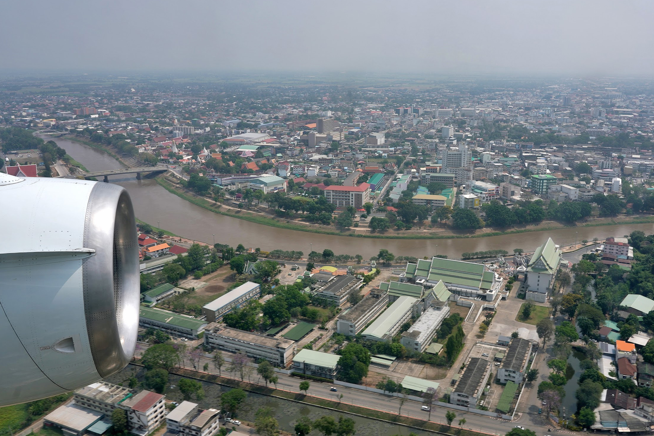
NASA scientists are in the fray, collecting data that will make it easier to confront the air quality challenge. In spring 2024, an international field campaign—Asia-AQ (Airborne and Satellite Investigation of Asian Air Quality)—headed to Thailand to sample the haze. NASA’s DC-8 flew several flights over Chiang Mai and the surrounding region. The photographs above—showing haze above the Ping River in Chiang Mai and inlets for sampling air quality on the DC-8—were taken on March 18, 2024. The Asia-AQ team will use the data to refine models of how the region’s haze forms, evolves chemically over time, and moves throughout the region.
NASA teams are also working with partners in the region and the USAID-NASA SERVIR program to develop tools designed to inform people about haze and smoke during the fire season. For instance, SERVIR Southeast Asia has worked with the Royal Thai Government’s Pollution Control Department to develop the Mekong Air Quality Explorer tool, a monitoring and forecasting tool that combines data from ground sensors and satellites. “It should help authorities in Thailand devise data-driven policies and strategies to tackle air pollution,” said Aekkapol Aekakkararungroj, a geospatial manager with SERVIR Southeast Asia.
NASA Earth Observatory images by Michala Garrison and Wanmei Liang, using Landsat data from the U.S. Geological Survey. Asia-AQ is a joint effort between NASA and Korea’s National Institute of Environmental Research and several international organizations including the Department of Environment and Natural Resources Philippines, the Universiti Kebangsaan Malaysia, the Geo-Informatics and Space Technology Development Agency Thailand, and the Ministry of Environment Taiwan. Photographs by Rafael Luis Méndez Peña (NASA Earth Science Project Office). Story by Adam Voiland.