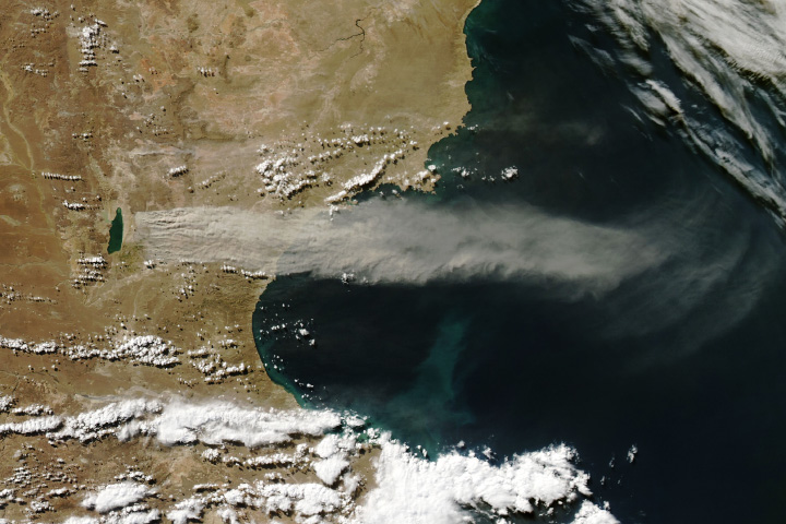
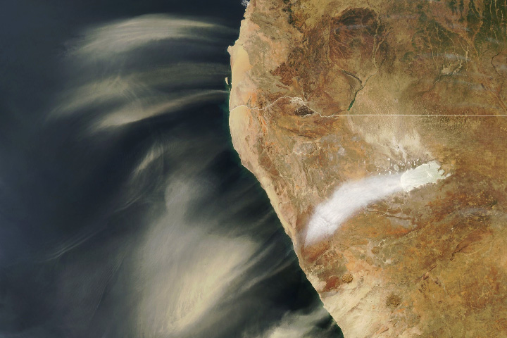
Strong northwesterly winds often race down the eastern side of the Andes Mountains and whip across the central Patagonian Desert. In the process, they sometimes lift dust from Argentina’s drying Lago Colhué Huapi, fueling intense dust storms.
The MODIS (Moderate Resolution Imaging Spectroradiometer) on NASA’s Aqua satellite acquired this natural-color image of dust streaming from the silty lakebed, east of Lago Musters, on March 29, 2024. Lago Colhué Huapi is a particularly rich source of dust because the shallow lake regularly grows and shrinks with variations in the flow of the Senguer River and the pace of evaporation. When lake water levels are low, as they were when MODIS captured this image, fine-grained, lightweight particles are easily transported by the wind.
To better understand dust activity from Lago Colhué Huapi, NASA scientists have analyzed satellite and surface weather data over five decades, assessing the year-to-year variability in dust storms and identifying periods of high activity. Dust storms peak during the summer (December through March), though events in the wintertime (May through August) are also common. Most years have 15 to 30 moderate to large dust events.
Dust storms are frequent and persistent enough in this area that they have exposed an open-air archaeological site along the lake’s edge. The Puesto Roberts 1 site, located in an old floodplain on the southeast side of Lago Colhué Huapi, was first identified in 2019 when archaeologists noticed that winds had exposed a five-centimeter layer of sandy loam soil littered with stone tools and the bones of a wild species of llama called guanaco.
Archaeologists identified 427 artifacts at the site—including stone cutting blades, milling tools, scrapers, and egg-shaped bola stones used for hunting—spread across 15 square meters, according to a 2022 study led by Heidi Hammond, an archaeologist at the National University of the Patagonia San Juan Bosco. The artifacts, which are roughly 1,500 to 1,000 years old, are thought to be the remains of a temporary campsite where people cleaned and ate guanaco. Most of the stones were made of chert, a locally available fine-grained sedimentary rock, but researchers also found examples of quartzite, andesite, basalt, xilopal, rhyolite, black obsidian, tuff, silicified tuff and gneiss artifacts.
In assessing the size distribution of the artifacts, the smallest artifacts were notably scarce. “Due to the strong erosive action of wind,” the authors noted, “these types of pieces were probably mobilized and therefore their representativeness in the assemblage is low.”
NASA Earth Observatory image by Wanmei Liang, using MODIS data from NASA EOSDIS LANCE and GIBS/Worldview. Story by Adam Voiland.