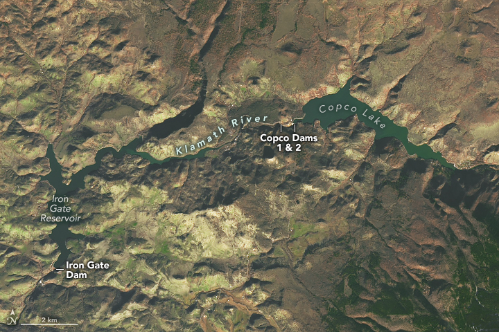
The Klamath River in southern Oregon and northern California is now running freer. In late 2023 and early 2024, four of the six dams along the river were breached and reservoirs drained. These actions were part of an effort to restore hundreds of miles of riparian habitat. It is thought to be the largest dam removal project in history.
The four dams—Iron Gate, Copco No. 1, Copco No. 2, and J.C. Boyle—were built between 1918 and 1962 to generate electricity. Facing steep costs to modernize them in the early 2000s, the utility that owned the dams opted for deconstruction instead. In addition to removing aging infrastructure, the project is expected to eliminate the ecosystem and human health risks posed by toxic algae, which has regularly reached harmful levels in the reservoirs since 2005. Restoration efforts will focus on revegetating hundreds of acres and reinvigorating fish populations in what was once the third most productive river for salmon on the West Coast.
The first dam to be removed, Copco No. 2, was also the smallest; that project wrapped up in September 2023. Copco No. 2 did not impound a reservoir but rather diverted the river’s flow through a tunnel system to a powerhouse downstream.
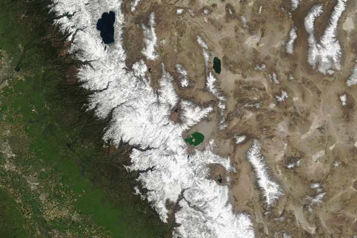
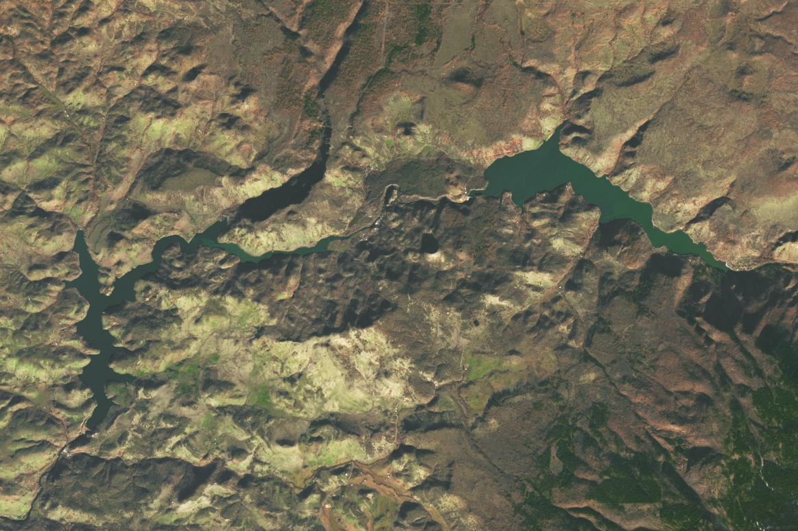
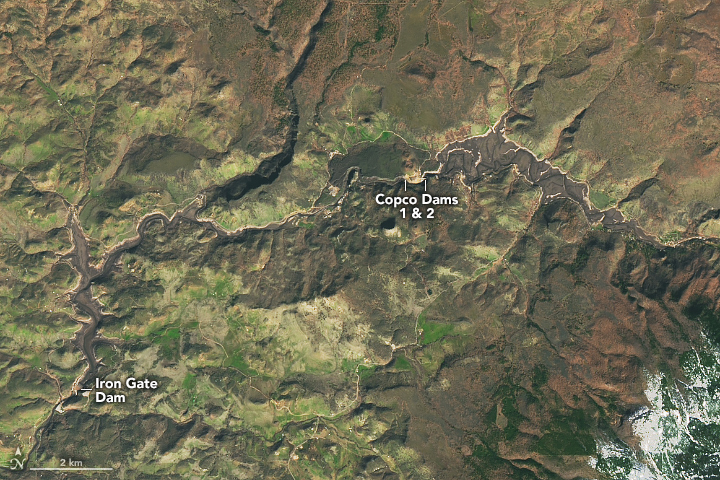
More-visible changes would come later, after the image on the left was acquired with the OLI-2 (Operational Land Imager-2) on Landsat 9 on December 23, 2023. At that time, the Iron Gate, Copco No. 1, and J.C. Boyle (upstream and not in view) dams were still holding back water. Drawdown of the Iron Gate Reservoir began on January 11, 2024, followed by the controlled release of water from Copco Lake and J.C. Boyle Reservoir.
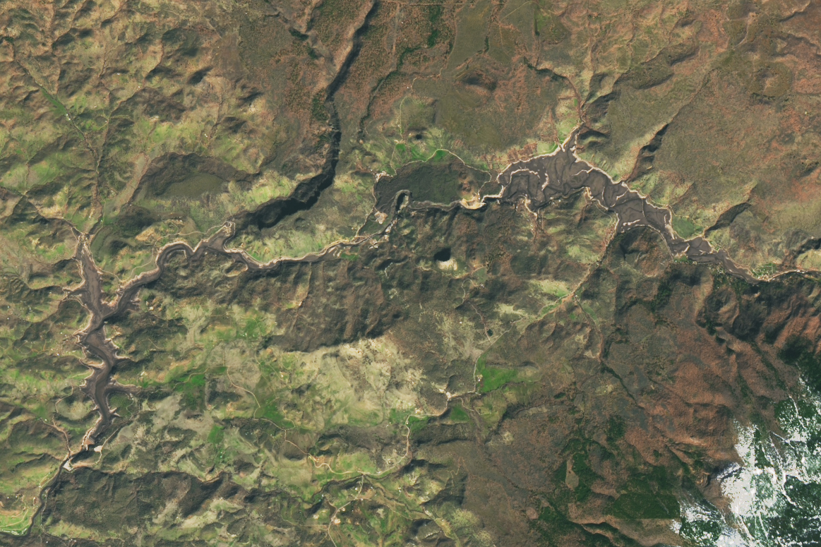
By February 15, the initial phase of drawdown was complete, according to a news release from the Klamath River Renewal Corporation (KRRC), the organization managing the project. The result is evident in the second image (right), acquired with the OLI-2 on Landsat 9 on February 25. A river channel meanders through the beds of the drained reservoirs.
The KRRC estimated that 5 million cubic yards of sediment previously held behind dams would travel downstream during this drawdown phase. Scientists expect the release of sediment early in the project to degrade water quality in the near term, increasing turbidity and lowering dissolved oxygen content. “The river is undoing a century of being impacted by these dams, and that may look messy right now,” said NOAA fisheries biologist Shari Witmore in a statement.
A steady supply of river sediment will help build up habitat for organisms downstream, transport nutrients, and replenish coastlines over the long term. The Klamath is one of many river systems, especially in the Northern Hemisphere, to have gone without many of these benefits for decades. A recent analysis of Landsat and hydrological data found that 20th-century dam building in North America, Europe, and Asia has halved the global delivery of suspended sediment from rivers to the oceans relative to pre-dam conditions.
Researchers have documented rapid and long-lasting ecological gains following other dam removal and river restoration projects, such as the one on the Elwha River in Washington state in the 2010s. To jumpstart restoration on the Klamath, NOAA Fisheries, the Bureau of Reclamation, tribes, and other partners are conducting controlled water releases from dams farther upstream to maximize the movement of sediment and minimize impacts to fish.
In the coming months, the three remaining dam structures will be completely disassembled. The removal of Copco No. 1, a concrete arch dam, began in March; Iron Gate and J.C. Boyle, both earthen dams, will be deconstructed after the spring runoff period. The removal of all three is slated to be complete before the fall Chinook salmon run. Restoration of the approximately 1,300 acres that were previously underwater has already begun with the dispersal of climate-adapted seeds collected throughout the watershed.
NASA Earth Observatory images by Michala Garrison, using Landsat data from the U.S. Geological Survey. Story by Lindsey Doermann.